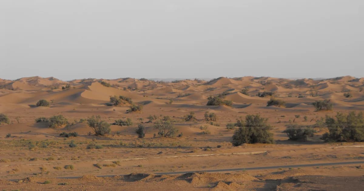

A dune gives the eye a ridge to follow. Stony ground draws attention downward, towards the material underfoot. A riverbed asks a different question: where has water passed, and what has it left behind? Reading the desert around M’Hamid begins with noticing these differences before giving the whole view one name.
Our M’Hamid introduction establishes the wider setting. This field note looks at its physical forms: loose sand, rock fragments, plateau terrain and channels. The aim is a more precise vocabulary for what a photograph or landscape description shows, with the processes kept close to the evidence.
At a glance
- M’Hamid’s documented setting includes river, lake and dune deposits, rather than sand alone.
- A dune is an accumulation of loose sand; gravel cover and rocky plateau terrain describe different features.
- A channel remains a landform when surface water is absent; its appearance can change with flow.
- Wind and water both move sediment, but a photograph alone cannot reconstruct a surface’s full history.
More than a sea of sand
M’Hamid sits within a landscape assembled from different materials. In the study-area section of their 2019 alluvial-aquifer paper, Anna Szczucińska and colleagues place the oasis between Jebel Bani to the north and Hamada du Dra to the south. Printed page 84 describes a depression containing alluvial fans, river deposits, lake deposits and dune deposits.
The names identify different kinds of evidence. Alluvial material is sediment deposited by flowing water; lake deposits belong to a different setting from wind-built dunes. The authors also describe the lower river terrace they studied as containing gravels and cobbles. A stony surface in this region need not have the same origin as the sand beside it.
For a first reading, separate shape from material. A ridge is a form; sand is a material. A channel is a form that can contain several materials. Making that distinction helps us describe a scene without assuming that everything visible was formed by the same process.
Dunes: where loose sand gathers
A dune is a mound of loose sand built by wind. The National Park Service’s account of aeolian landforms describes a common profile with a gentler windward slope, a crest and a steeper lee side. Aeolian simply means related to wind action. The explanation is general geology, not a classification of every dune near M’Hamid.
In the cover photograph, a series of raised sandy forms extends behind the flatter foreground. Scattered vegetation interrupts the view. Follow one ridge and then another: the repeated relief is clearer than it would be in a description that calls everything “sand.” There is no need to assign the plants a species or the dunes a formal type to notice that contrast.
Our Erg Chegaga field note follows dune forms and smaller sand ripples more closely. Here, the dune is one part of a comparison. Its loose grains and raised form give us a starting point for looking at flatter, coarser or more rocky ground.
Stony ground: surfaces with different histories
Stony ground is not one geological category. A layer of separate pebbles differs from continuous exposed rock, even when both appear brown or grey from a distance. The National Park Service’s arid-landforms guide describes desert pavement as a closely packed surface of coarse pebbles and gravel. The term describes an arrangement at the surface, not every place where stones are visible.
Two words also help when reading French-language accounts of the Sahara. The Académie française’s entry for reg describes desert ground covered with rock fragments exposed through wind erosion. Its entry for hamada refers to a rocky plateau in African desert regions. These dictionary senses distinguish a fragment-covered surface from a broader plateau form.
They are useful vocabulary, not labels to attach automatically to an unidentified photograph. Around M’Hamid, the river-terrace gravels described in the 2019 study offer another reason to keep the material’s setting in view. “Covered with pebbles” is an observation; “formed entirely by wind removing finer grains” is an explanation that requires further evidence.
Try describing the ground before choosing a name. Are the stones separate pieces, or part of a continuous rock surface? Does the surface form a broad raised area, an inclined edge or a flat patch? Those observations make a later identification more meaningful.
Dry riverbeds: the shape left by water
A channel is more than the water visible within it. Its bed and edges remain part of the terrain between flows. The Académie française defines oued as a North African river, particularly an intermittently flowing watercourse in an arid region. The word does not mean that every reach is permanently dry.
The Draa provides a local connection. Szczucińska and colleagues describe it as intermittent and explain how infiltration into alluvial material supplies groundwater in the M’Hamid study area. Their fieldwork dates to October 2015. This account helps distinguish the channel, surface flow and water stored below ground, without turning an older study into a present-day water report.
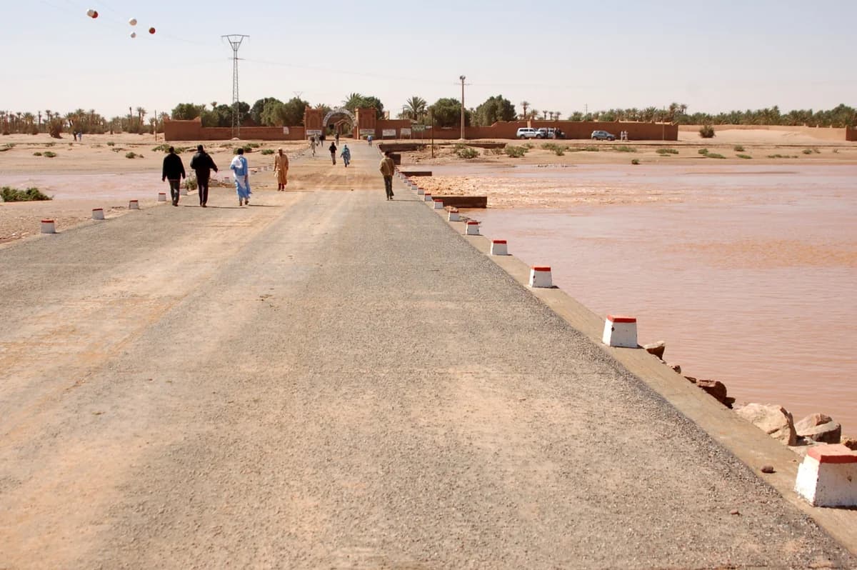

The photograph gives the discussion a useful counterpoint. Water occupies part of the channel beside the crossing, while people, palms and buildings establish a lived-in setting. Its date belongs with the view. A dry photograph taken at another time would tell a different part of the river’s story, rather than cancelling this one.
The Draa Valley article follows the river at a wider scale. Here, the important distinction is between a channel’s form and its condition at the moment it is seen.
One landscape, connected processes
Wind and water belong in the same explanation of desert terrain. The NPS aeolian guide notes that wind-driven processes rely on other geological agents, including rivers, to supply sediment. Its arid-landforms guide describes alluvial fans forming as streams enter flatter ground, slow and deposit material. Those are general processes, not a reconstructed itinerary for a particular M’Hamid grain.
This comparison keeps the scale of each term visible:
| Feature or term | What it describes | First thing to notice |
|---|---|---|
| Dune | A mound of loose sand built by wind | Ridges, crests and slopes |
| Reg | A fragment-covered desert surface in the dictionary sense above | Separate stones and the material between them |
| Hamada | A rocky desert plateau | The broader raised terrain, not just one stone |
| Channel or oued | A watercourse and its physical bed | Edges, sediment and whether surface flow is visible |
The table compares features and words, not four neat zones that must occur in a fixed order. A plateau term concerns broader relief; a surface description can concern a much smaller patch. Keeping those scales separate is more useful than trying to divide every scene into matching boxes.
Looking more closely
Begin with what can actually be described. These prompts work for studying a photograph as well as discussing a place with someone who knows it:
- Material: is the visible surface loose sand, separate stones, continuous rock or a mixture?
- Shape: where are the ridges, flatter areas and breaks in slope?
- Water: can you trace a channel edge, and is water visible in this dated view?
- Names: which terms come from a published source, and which local names still need confirmation?
- Change: what would a second photograph, taken from the same position on another date, help establish?
A precise description can stay modest. “Pebbles cover this patch” records something visible without guessing its entire geological history. “Water is visible beside the crossing in March 2009” says more than calling the river either wet or dry forever.
The next connection is life in the M’Hamid oasis, where water, cultivated ground and work meet. Landscape vocabulary helps us look more carefully; local knowledge can add names, remembered changes and meanings that a geological description cannot supply by itself.
Editorial note
This research edition belongs to the NomadeTrip editorial project. Its relationship with a sister travel business is disclosed separately. AI assisted research and writing. A named human editor, local review and a correction/contact pathway still need confirmation.
Sources were checked on 23 October 2026. Local geological context comes from the 2019 paper’s study-area account, especially printed page 84; its fieldwork was conducted in 2015. NPS pages explain general landforms, while the Académie française supplies dictionary meanings rather than a survey of local speech. No original sediment sampling, field visit, interview or current hydrological measurement is claimed.
Both photographs are dated historical views with visible licence credits. No suitable verified stony-ground photograph was identified for this edition, so no unidentified image has been labelled as a local reg or hamada. This introduction provides no route, access or present-condition advice. The proposed canonical address is not yet a published article.