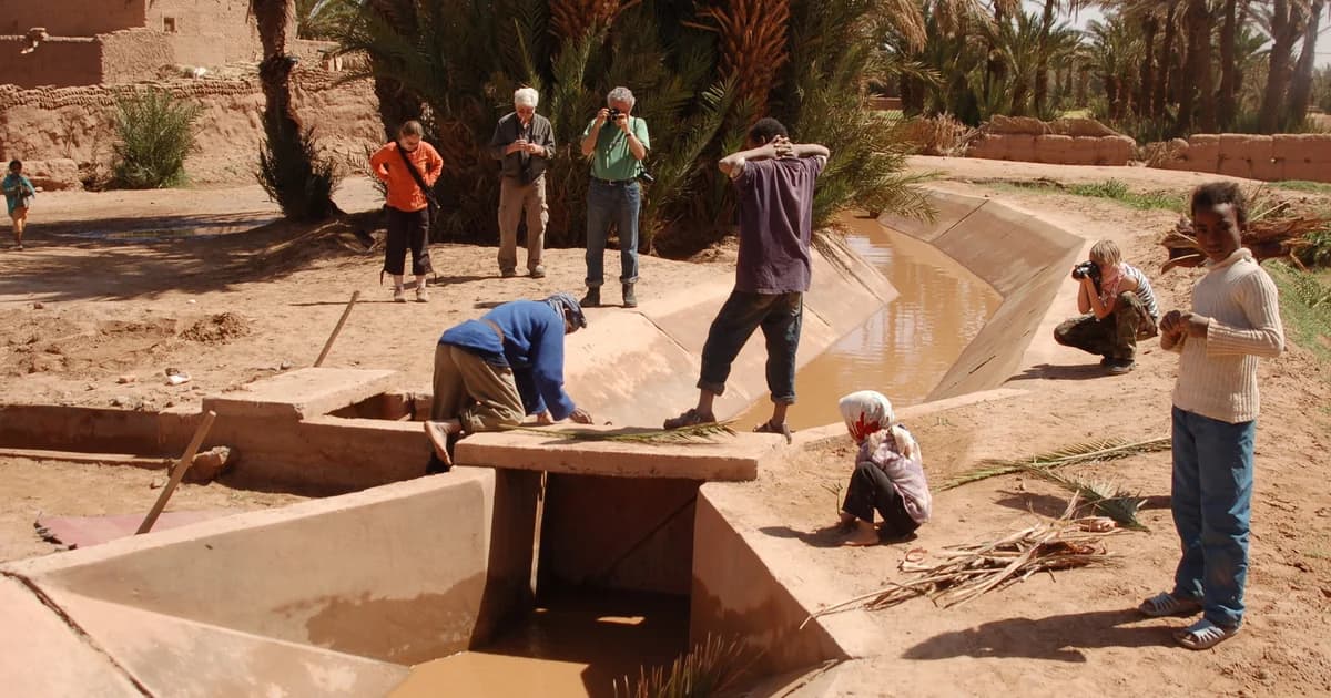

An oasis deserves a closer reading than a patch of green beside the dunes. In M’Hamid, research connects cultivated land with irrigation, household decisions and the work available to keep a field in use. The photographs here offer dated views, not a promise that every garden looks the same today.
Our M’Hamid introduction places the oasis in its wider surroundings. This field note looks closer: where water goes, what a palm garden can contain, and why a planted landscape cannot be understood without the people who work it.
At a glance
- Oasis farming combines land, water and continuing work; palms alone do not explain it.
- The familiar three-layer garden is a wider Moroccan oasis model, not a verified description of every M’Hamid plot.
- Research from October 2015 documents irrigation channels and groundwater salinity in M’Hamid.
- Older fieldwork helps explain farming decisions, but current crops, routines and water-sharing arrangements still need local verification.
An oasis is a working landscape
A palm grove is also an agricultural system. Garbati Pegna and colleagues’ 2017 paper, Sustaining Moroccan Oasis Agricultural System through Small Mechanization Inputs, describes the linked care of plants, soil and water across Moroccan oasis agriculture. Its scope covers several regions, rather than a survey of M’Hamid alone.
For a reader, that changes the questions worth asking. A photograph can show green fields; it cannot tell us whose work sustains them, which plots are cultivated this season or how water reaches their edges. Those details need a place, a date and someone able to explain them.
The Draa Valley field note follows the larger landscape. Here, the useful scale is a field and its connections: the channel beside it, the approach from a home, and the decisions that precede planting.
Under the palms: a model, not a uniform garden
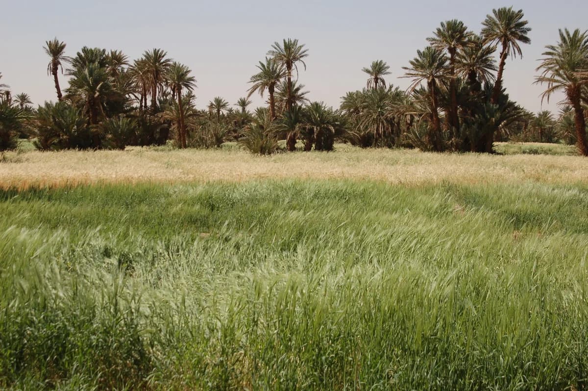

The three-layer oasis model puts date palms above fruit trees, with crops nearer the ground. In the 2017 agricultural paper, the palms help shelter lower vegetation from strong sun. The authors describe this arrangement in many oases, not every plot.
That distinction matters in the Draa Valley. Section 3.5 of Ait Lamqadem and colleagues’ 2018 land-cover and desertification study places its dense, three-layer example in Ternata. Its description of the southern Ktaoua and M’Hamid areas instead includes degraded palms and alfalfa, a fodder crop. These grouped observations are not a complete inventory for either oasis.
The historical photograph above gives a different kind of evidence: visible grain fields in one view of M’Hamid. It does not identify every plant or show the whole oasis. Read the model, study and photograph together without making them interchangeable.
Following water from channel to field
Water must reach the cultivated plot, and its quality matters as well as its presence. Dłużewski, Kozłowski and Szczucińska’s 2017 M’Hamid groundwater study describes water moving through concrete main canals into secondary channels serving fields, with pumped wells supplementing irregular releases from the Mansour Eddahbi reservoir.
Their October 2015 campaign sampled 42 wells. The researchers found substantial salinity and variation in groundwater suitability across the oasis. Different assessment indices did not give identical classifications. The findings should not be shortened to either “well water solves the problem” or “nothing can grow here.” Nor do these samples establish the quality of any well today.
Alluvial groundwater means water held in the sediments associated with a river. In this account, the distinction between river supplies, channels and wells helps explain the system; they are not separate guarantees of dependable water.
The work behind a cultivated field
Farming decisions include which land can be worked, not just which crop to plant. In section 19.5 of Karolina Sobczak-Szelc’s chapter on M’Hamid, first published online in 2023, research from 2015 to 2019 describes households selecting fields partly by expected water supply and distance from canals and home.
The chapter combines questionnaires, interviews, observation and environmental evidence. Its interview accounts also describe older cultivators, relatives working elsewhere and difficulty finding people available for fieldwork. These are attributed research findings, not conversations conducted for this archive or a census of every household.
Work also extends beyond what a wide photograph reveals. The broader 2017 Moroccan oasis paper identifies date-palm pollination, pruning and harvesting among operations considered in its analysis of equipment and labour. This provides context, not evidence for who performs each task in a particular M’Hamid family.
The Ouled Youssef entry approaches another form of practical knowledge: building and caring for earthen architecture. Both subjects deserve accounts that identify the people doing the work, with their consent.
A changing oasis, read through dated evidence
Change cannot be read from a single green or dry view. The 2018 Middle Draa study combines satellite information with environmental indicators to assess sensitivity to desertification. Its southern-area findings concern a studied landscape and method, not a prediction that each M’Hamid garden will follow the same path.
Sections 19.5 and 19.6 of Sobczak-Szelc’s M’Hamid household research connect water constraints with reduced cultivation and choices about work and mobility. Distance to a field and available labour also enter the account. It would miss that complexity to describe every uncultivated plot simply as the result of drought, or every departure as the same kind of decision.
The water study and household chapter overlap in their environmental references. Repeating an older measurement in a later publication does not create a second measurement. Their value is in showing different parts of the problem, while keeping their study periods visible.
Continuing the record with local knowledge
The next contribution should add detail that publications cannot supply for us. With a willing local contributor, a useful starting point would be one garden or channel, rather than an account claiming to represent the entire oasis.
Questions for that conversation could include:
- What names do people use for this plot, channel and farming tasks?
- What was planted here this season, and what informed that choice?
- How is maintenance organised, and which details should remain private?
- Which changes does the contributor remember, and from what period?
- How would they like their account and photographs credited?
These are proposed interview questions, not answers already collected. Any contribution needs consent, attribution and an opportunity for correction. The developing living-culture collection is a place to connect such knowledge without reducing it to scenery.
Editorial note
This research edition belongs to the NomadeTrip editorial project. Its relationship with a sister travel business is disclosed separately; no booking recommendation is made here. AI assisted research and writing. A named human editor, local review and a correction/contact pathway still need confirmation.
Research was checked on 22 October 2026. This is a historical and explanatory synthesis, not a report of current conditions. The household chapter was first online in 2023; its principal fieldwork dates from 2015 to 2019. The groundwater measurements date from October 2015. The wider oasis paper and regional land-cover study have different geographic scopes, stated beside their use.
Both photographs date from March 2009. Their creator, location descriptions, reuse licence and changes are identified in the captions. No original interviews, farm visits, current water tests or present-day crop counts are claimed. The canonical address is a proposed publication location; this local draft is not yet published.