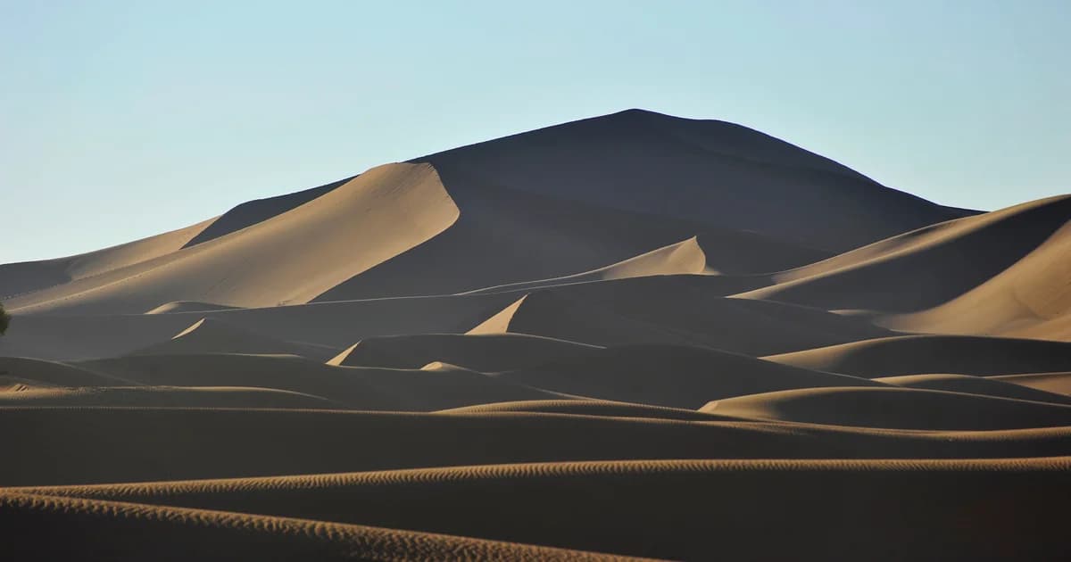

Erg Chegaga is a field of Saharan sand dunes in southern Morocco. The Moroccan National Tourist Office names Chegaga among the dune landscapes of the Ouarzazate, Zagora and Tinghir region. It is a place to study as well as to photograph: a surface shaped by moving grains, within a wider desert that also contains oases and temporary wetlands.
Begin with M’Hamid El Ghizlane, the oasis settlement that anchors this guide. Then look beyond the familiar sunset view. A dune crest, a patch of ripples and a dry basin each tell a different part of the desert’s story.
At a glance
- An erg is a field of sand dunes, not a name for every kind of desert.
- Wind moves grains across dunes; small surface ripples and large dune forms are not the same feature.
- The wider Iriki setting includes a temporary wetland whose conditions depend on water.
- Regional cultural sources describe named traditions and people, not a single anonymous “desert culture.”
Begin with a dune field, not an empty space
Chegaga belongs in a regional picture that includes settlements, cultivated ground and other desert surfaces. The tourism office’s regional nature page places dunes alongside the Drâa palm groves and Iriqui National Park. These are different environments, not interchangeable names for one sandy scene.
For orientation, the tourism office’s Hidden Gems brochure associates M’Hamid, south of Zagora, with Erg Chegaga. It separately associates Merzouga with Erg Chebbi. Chegaga and Chebbi are different dune fields, reached through different settlements. That is a useful distinction before reading a regional map, but not a route description.
The word erg makes that distinction useful. In its explanation of a different Saharan sand sea, the U.S. Geological Survey identifies the term with a field of dunes. That definition helps describe Chegaga without treating the whole Sahara as a continuous heap of sand. Erg Chech, the Algerian place shown on the USGS page, is not Chegaga; its photograph is not used here.
The scale of attention changes with the question. A wide photograph shows dune ridges. A closer view reveals grains and ripples. Regional sources describe the connections between named places. None of these views replaces the others.
How wind gives sand its shape
Wind can carry grains up a dune’s gentler slope and leave them near its crest. When too much sand gathers at the edge, grains slide down the steeper face. The USGS explanation of eolian processes describes this repeated movement as a way dunes advance. Eolian, also written aeolian, means shaped or transported by wind.
Sand can move in short hops, called saltation, or roll along the ground. The dune is not travelling as a solid block. Its form changes as grains are removed from one part and deposited on another. This is a general explanation of dune movement, not a measured rate for Chegaga.
Wind direction matters too. The USGS account of dune types distinguishes crescentic, linear, star, dome and parabolic forms. Different wind patterns and conditions can produce different shapes. A photograph alone is not enough to classify an entire dune field or establish how quickly it is changing.
Look at the cover’s contrast between the lit slope and the dark face. It makes the dune’s relief visible. It does not reveal the wind history that built that particular dune, and the photograph’s 2018 date should stay attached to the view.
Read the smaller marks
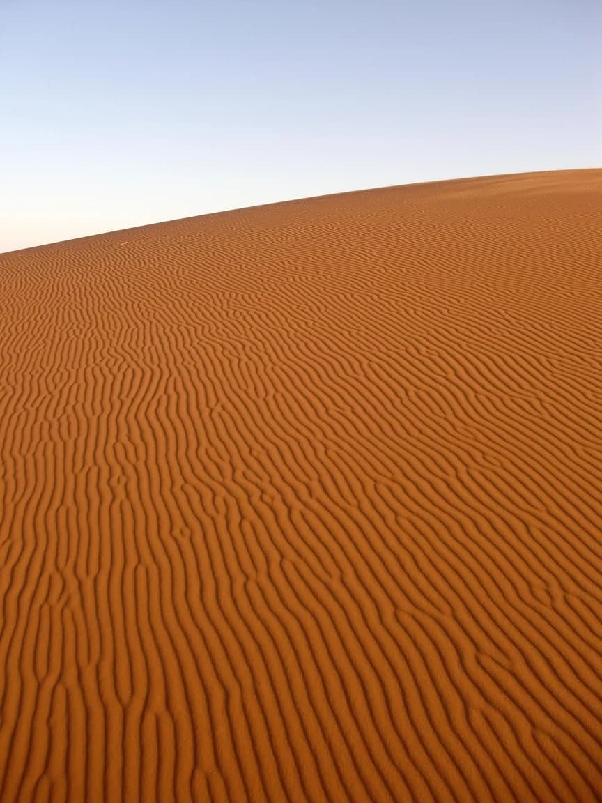

Surface ripples let the eye follow wind’s work at a smaller scale. The USGS describes wind-deposited sand as occurring in sheets, ripples and dunes. Ripple crests can run across a dune’s surface; the dune itself is a much larger landform.
In this historical photograph, repeated lines cross the sand close to the camera. Reading those marks is a more precise starting point than calling every curve a dune. The visible pattern is evidence of the photographed surface, not a survey of present conditions.
For unfamiliar terms, keep the desert glossary beside the photographs. Start with the broad distinction between a sand sea, an individual dune and marks on its surface. More detailed identification needs observations of the site and its winds.
Iriki: a dry view does not tell the whole story
Iriki is described as a temporary wetland in the wider desert region. The Association Marocaine pour l’Ecotourisme et la Protection de la Nature, or AMEPN, places the lake between Foum Zguid and M’Hamid. Its park description says the basin is often dry but can provide a stopping and wintering place for migratory waterbirds in wet periods.
That qualification changes how a visitor should read the word lake. It does not promise open water on arrival. Equally, a photograph of dry ground cannot establish that water has disappeared permanently. The association identifies wetland rehabilitation as one of the park’s purposes.
AMEPN also describes vegetation that includes acacia and tamarisk in different park habitats. Those descriptions concern the wider park, not a plant inventory for every Chegaga dune. They give another reason to look beyond a sand-only image of the region.
No current water level, wildlife count or species sighting is claimed here. The source is an undated conservation overview, checked for this draft, rather than a live field report. Its proposed reintroductions must not be read as proof that animals are already present.
Keep people and their accounts in the picture
Regional desert knowledge has identifiable speakers. In an interview published by the Moroccan National Tourist Office, guides and runners Lahcen and Mohamad Ahansal discuss their upbringing and work in the Zagora region. Mohamad describes a connection to Chegaga; Lahcen explains collecting litter when taking groups into the desert. These are their published accounts, not interviews conducted for this guide.
Culture also needs more specific names than “nomadic music.” Joudour Sahara’s regional documentation identifies several southern Drâa traditions, including Chamra and Rokba, and describes work to record, practise and transmit them. These are regional contexts. They do not establish which traditions any particular Chegaga household practises.
The next contribution should come from a person willing to explain a place name, a remembered route or a change they have observed. Their name, preferred community description and permission to publish matter. A landscape guide should not turn an unnamed person into scenery. The people collection is the intended home for more carefully attributed accounts.
Visit with attention, not assumptions
Begin with local guidance rather than treating this article as a route description. The tourism office recommends exploring the regional landscapes with a guide. This draft supplies no driving track, crossing instructions or guarantee of access.
For a visit, the editorial principles are simple:
- Take litter away rather than leaving it for the wind or a host to remove.
- Ask before photographing people, homes or working spaces; accept a refusal.
- Ask hosts how water is supplied and what use is reasonable.
- Observe plants and animals without collecting, feeding or disturbing them.
- Seek current local advice about conditions before planning movement beyond settlements.
These are recommendations for respectful conduct, not a claim that one checklist proves a business is sustainable. Lahcen Ahansal’s published account of carrying a rubbish bag offers one concrete example. Broader claims about a camp’s water use or environmental impact would need evidence from that operation.
Follow one connection further
Chegaga becomes easier to understand when the dune is connected to its grains, the regional basin and the people describing the place. Keep those connections specific. A general lesson about wind is not a local measurement; a park overview is not a current wildlife survey; one person’s testimony is not every family’s history.
Continue with the desert collection, or return to the oasis introduction with a question to investigate. A locally reviewed place name or a carefully dated observation would add more to this archive than another unsupported claim about the “highest” dunes.
Editorial note
This draft is attributed to the NomadeTrip editorial project, an independent archive of place, memory and living culture around M’Hamid and the Sahara. Its purpose is explanation rather than tour sales. The organizational byline identifies the project receiving this proposed contribution; it does not claim that a human editor has reviewed it.
Public institutional, geological and community sources were consulted on 21 October 2026, with AI assistance for research and writing. The three USGS pages were also fetched directly and their supporting text preserved in the local research record after the web-search reader encountered access errors. The dune-process pages are older educational material, last modified in 1997, used for general principles rather than present-day measurements. The photographs retain their creators, dates, licences and alteration notes. No original fieldwork, interview, measured dune height or current environmental survey is claimed.
Human editorial responsibility and local review remain pending. Before publication, check the regional orientation and place-name spellings with a consenting local contributor, and provide a genuine correction/contact pathway. The proposed article URL is not evidence of publication. No commercial booking link or invented expert biography is included.