
The Draa Valley, also written Drâa Valley, is a useful place to begin understanding the Sahara through cultivation rather than dunes. This introduction follows the middle Drâa, the oasis corridor between Agdz and M’Hamid identified by the University of Leicester’s Middle Draa Project. Here, the questions are about gardens, settlements and the work that connects them to water.
Following the river means following those connections. It does not mean expecting an unbroken ribbon of flowing water or tracing a driving route. A palm grove, an irrigation channel and an earth-built wall each offer a different way into the landscape. At the southern end of this introduction is M’Hamid El Ghizlane, already the starting point of this archive.
At a glance
- This article concerns the middle Drâa corridor, not every part of the river basin or the wider Drâa-Tafilalet region.
- Traditional oasis agriculture combines cultivated plants with human knowledge and water management.
- Water allocation and groundwater matter alongside the visible riverbed.
- Dated photographs and research explain particular places and periods, not conditions on a future visit.
Inside this field note
A valley, not a continuous ribbon of water
Start by separating the river, its basin and the cultivated places along it. They are connected, but they are not interchangeable. In the middle Drâa, Agdz and M’Hamid are useful reference points for the scope of this introduction. The much broader name Drâa-Tafilalet also appears in regional programmes; a project in that administrative region is not automatically a project at every oasis on this corridor.
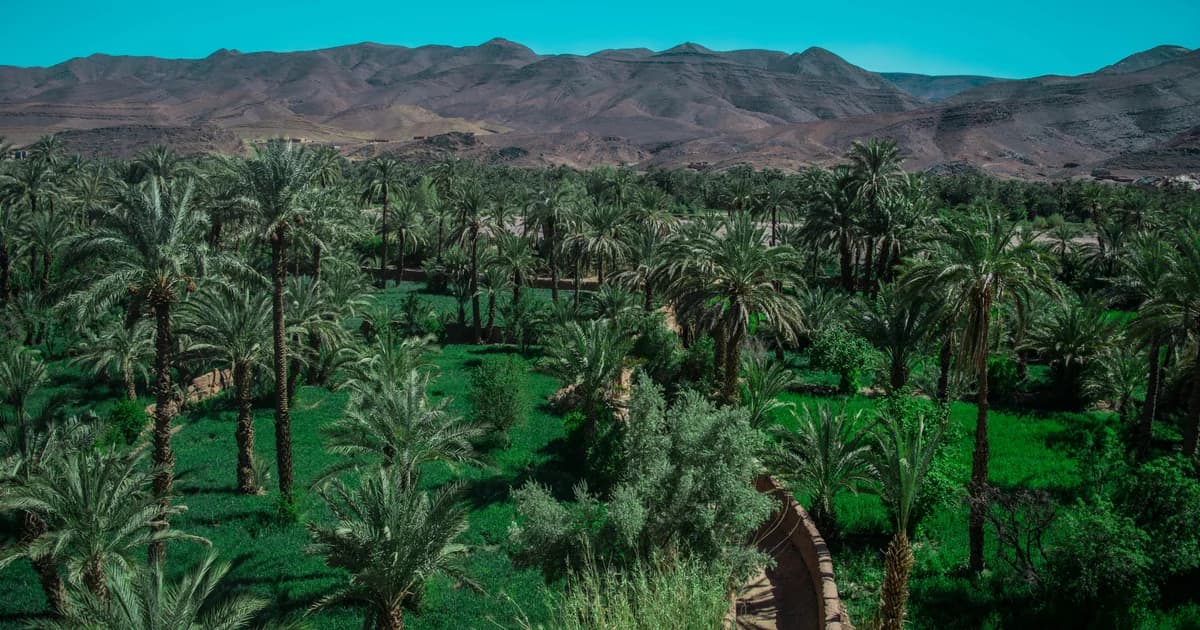
The cover photograph makes the distinction tangible. It shows Agdz in April 2018: palms, green plots, a narrow channel and bare hills beyond. It does not show the whole valley. Nor can it establish how much water reached a different garden, then or now.
Read the picture from the ground upward. The small plots and channel deserve as much attention as the palm canopy. Their visible arrangement gives the eye a starting point; the explanation needs agricultural and water-management sources. A green view is not, by itself, proof of a secure water supply.
For unfamiliar landscape terms, the developing desert glossary provides a place to continue. Keep the distinction between a named place and a general landform in view.
How an oasis works
An oasis is cultivated space, not simply a cluster of palms appearing naturally in the sand. Antonio Santoro’s review of traditional North African oases, published online in 2022, describes farming systems that combine date palms, fruit trees, lower crops and livestock. Its geographic scope is broader than the Drâa, so it offers a framework rather than an inventory of every local garden.
The review describes a layered arrangement:
| Level | Plants described in the review | What to check locally |
|---|---|---|
| Upper | Date palms | Which varieties grow in this plot? |
| Middle | Fruit trees, including olives | Is this layer present here? |
| Lower | Vegetables and fodder | What is cultivated in this season? |
That model is useful precisely because it invites closer questions. It should not become a claim that every plot has all the layers, the same crops or the same condition. The review also distinguishes these mixed traditional systems from modern, more uniform date plantations.
In the Agdz photograph, the palms rise above smaller trees and green plots. A channel passes between cultivated areas. These visible details make the idea of mixed cultivation easier to grasp, although the image does not identify each crop. Start with that arrangement rather than assuming the grove is a date plantation alone. The living-culture collection contains developing topic previews, not a completed account of this garden or its growers.
Sharing water connects the oases
The visible channel is only part of the water story. A 2025 study of groundwater governance in the Middle Drâa Valley examines Faija, Fezouata and M’Hamid as distinct cases. For M’Hamid, the researchers explain that recharge depends partly on releases from the Eddahbi Dam, alongside other sources, and that allocations are connected to upstream demand.
The study also describes collective wells and community rules for sharing their water. Its M’Hamid research included interviews with farmers and tourism-facility owners in 2022. Those are the researchers’ interviews, not conversations conducted for this article. They help explain water management as a social arrangement as well as a physical system.
This changes the questions worth asking beside a channel. Where does its water come from? Who has access? Who maintains it? A single image cannot answer them, and the paper does not provide a live release schedule or a current reading for an individual well.
Water is therefore a connection between places and users, not just a blue line on an atlas. Reading the valley through that connection avoids treating the palm grove as a self-sustaining backdrop.
Earth-built settlements hold another kind of knowledge

Earth-built architecture deserves to be read as construction knowledge, not reduced to a matching colour in a desert photograph. Baglioni and colleagues’ 2010 investigation of Drâa Valley building techniques includes Tamnougalt among its study locations. It documents rammed earth and adobe used in different building parts, with palm wood, canes and earth in floors and roofs.
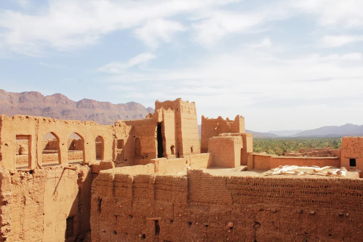
These are distinct materials and methods. The paper gives a reason to look carefully, but not permission to identify the technique of every photographed surface. The Tamnougalt image records visible walls and openings in 2020; it is not a building survey or a current access notice.
The Leicester project adds a longer time perspective. Its archaeological overview describes research on settlements, irrigation remains and other sites, using survey and dating methods. That evidence supports a history of changing settlement and cultivation. It does not make every visible structure the same age.
The photograph and the building study offer different kinds of detail. The image makes openings, wall surfaces and the palm grove beyond them visible. The study explains materials and techniques found at its surveyed locations. Archaeological dating addresses a further question: when particular remains belong in the valley’s history. Keeping those questions distinct is more useful than assigning the whole view a single age.
A changing landscape needs dated evidence
Environmental change should be described with its place, date and evidence attached. A FAO account published in August 2025 identifies water scarcity, climate change and deteriorating irrigation systems among the pressures on Drâa-Tafilalet oases. It describes the OASIL programme’s work on irrigation, erosion protection and local agricultural resources.
That report covers a wider region, not just the Agdz-to-M’Hamid corridor. Its programme achievements should not be read as proof that the channel in our cover photograph was restored, or that every local water problem has been solved. It is an institutional account of an intervention, not an independent assessment of every outcome.
Keep different kinds of evidence separate:
- A photograph records what was visible from a particular viewpoint on a particular day.
- An interview records what a named or properly described participant reported within a study.
- A model explores what might happen under stated assumptions; a forecast year passing does not turn its results into observations.
- A project report describes activities and reported results within its own coverage.
These distinctions leave room for change without inventing a present-day diagnosis. They also avoid a romantic story in which living communities exist only to illustrate a disappearing past. Current contributions should describe what people are doing, not merely what an outside observer imagines they have lost.
Arriving at M’Hamid, then looking beyond the dunes
M’Hamid gives this introduction a connection to the articles already in the archive. Read its oasis introduction for the settlement’s wider setting. Then continue to Erg Chegaga for a different scale of attention: wind, grains and dune forms.
Together, the subjects resist the idea of a single, uniform desert landscape. A cultivated plot is not a dune. A channel is not the same thing as the river, and a documented regional pattern is not every family’s account. Following those differences makes the connections more useful.
Read the two photographs together. The Agdz view draws attention to cultivated ground beneath palms; the Tamnougalt view brings walls and openings into the foreground, with a grove beyond. Neither picture contains the whole valley. Each makes a different relationship visible, between growing space and water, or between a settlement and its surroundings. They were taken in different places and years, so they are not a before-and-after comparison.
Return to the places collection with those questions in mind. The valley is worth reading through its work and knowledge, not only through the view from the road.
Editorial note
This draft belongs to the NomadeTrip editorial project, an independent archive about place, memory and living culture around M’Hamid and the Sahara. The organizational byline identifies the intended publishing project; it is not a claim of named human or local review.
Research was checked on 22 October 2026 using university, scholarly and institutional sources. The agroforestry review concerns several North African countries, the groundwater study compares distinct cases, and FAO’s report concerns the broader Drâa-Tafilalet region. Those limits remain attached to the claims. AI assisted research and writing. No original interviews, field measurements or firsthand travel observations are presented.
Human editorial responsibility, local place-name review and a real correction/contact pathway still need confirmation before publication. The proposed canonical URL is reserved for possible publication, not evidence that this draft is live. The two photographs retain their dates, creators, source links and licences. No bookings, sponsored recommendations or invented expert biography are included.